Measuring Tools
The Measuring tools of the toolbar contains tools to measure data.
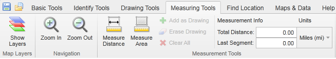
Measuring Tools tab of the toolbar
The tools in this tab are grouped into these sections:
Use this tool...  |
To... |
|---|---|

|
Measure distances on the map by drawing a segmented line. |

|
Measure an area of the map by drawing a shape. |

|
Add the distance or area measurement to the map as a drawing. |

|
Erase a drawing by clicking it. |
|
|
Clear all the drawings on the current map. |

|
Shows the final measurement of a drawing. This graphic is indicating the perimeter length and area of a polygon. |

|
Change the unit of measurement on a drawing to other options like Yards, Meters, Nautical Miles etc. |
See also...
Measure Distance and Area on the Map