Map/Data Display |

|

|

|

|
|
Map/Data Display |
|
|

|

|
Map/Data Display |
|
|
|
|
|
Map/Data Display |
|
|
|
|
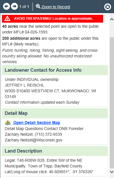
The Land Description dialog box will be displayed anytime you select lands enrolled in the tax program. The point that represents the data showing in the dialog box will be highlighted. Information displayed includes; ●Acres near selected point that are open to public recreation ●Additional acres (if any) that may be nearby that are under the same MFL or FCL number ●Type of activities allowed ●Landowner Contact ●DNR Forestry Contact ●Link to Open Detail Section Map for the Township-Range-Section on this MFL# (Map is not always available; contact local forester for information) ●Location including: PLSS legal description, municipality, and latitude/longitude coordinate of selected point ●Data update date ●Ability to Zoom To selected point
|
●If the ●The land enrolled in the tax law program will be outlined with purple or green lines. ●The land open for public recreation will also be highlighted in yellow.  Sample MFL map |
●The PLSS is a grid of survey lines and monuments forming approximate 6 mile by 6 mile townships across Wisconsin. Each township is divided into 36 - 1 mile by 1 mile sections of approximately 640 acres, but size can vary greatly. Each section is further divided into 16 quarter-quarter sections or what we commonly refer to as "40s". The acreage of each quarter-quarter section can vary, so a "40" may not actually be 40 acres in size. There are also other land descriptions called government and fractional lots. Government lots are often lands adjoining meandered water bodies. Fractional lots describe property in undersized or over sized sections.
 from www.nationalatlas.gov/articles/boundaiers/a_plss.html
●For a full description of the PLSS see the Wisconsin State Cartographer's Office https://www.sco.wisc.edu/introduction-public-land-survey-system/ or the Wisconsin Geological and Natural History Survey https://wgnhs.wisc.edu/pubshare/FS06.pdf ● |
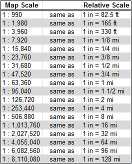
Map Scale is displayed on the green title bar on the upper left corner of the map Map scale is not specific to any measurement unit, that is, it is a ratio of 1 unit on the map equal to 'x' number of units on the ground. A scale bar Examples converting map scale to other units.
|
1.To turn on/off the aerial photo click or touch the Aerial box at the top. A checkmark indicates the photo is on. This is not available at all scales; you must be zoomed in to 1:63,360 or smaller. The aerial map is not available when the Topo map is selected. 2.To turn on/off supplemental map information click or touch the Map box at the top. This is available at all scales, but not when the Topo map is selected. A checkmark indicates the map info is on. 3.To turn on/off the Topo map click or touch the Topo Box at the top. A checkmark indicates the Top is on. When Topo is on, the other views are not available. 4.The Topo map cannot be displayed at the same time as the base map and aerial map. Turn off the Topo map to enable checking the Aerial or Map boxes. |
|